A single point on a map is not enough to explain a fire. However, an investigation that combines physical evidence, a timeline, and lightning data can establish a much more reliable origin. On October 18, 2026, the Michigan Department of Natural Resources (DNR) confirmed that lightning had sparked the Black River Fire in the state's Upper Peninsula.
This announcement provides a concrete example for operators of infrastructure exposed to storms: investigators have correlated the marks observed on cedar trees with the storm impact map. However, this official confirmation does not mean that a map can detect a fire, nor that a nearby impact automatically proves the cause of a disaster.
How can this analysis be organized without overinterpreting the data? Which documents should be kept and what role should be assigned to digital tools? Beyond the American case, this method helps managers of industrial, energy, or remote sites prepare a post-incident analysis. Above all, it allows them to distinguish between what was observed, what remains probable, and what falls within the scope of a competent investigator's conclusion.
Michigan: This is exactly what the October 18th press release confirms
A confirmation of the cause, not a new start date for the fire
The Michigan Department of Natural Resources' press release of October 18, 2026, confirms that the Black River Fire and the Craig Lake Fire were caused by lightning. However, the cause of the Ridge Fire remained under investigation at that time. The news, therefore, is the official confirmation of the fire's origin, and not the simultaneous outbreak of new fires on October 18.
The service describes a phased approach: review of weather event documentation, followed by ground observations when conditions become safer. For example, in Black River, charring marks on a group of cedar trees were corroborated by lightning strike mapping.
- Confirmed fact: lightning is the cause identified by authorities for Black River.
- Physical evidence cited: the pattern of tracks on cedar trees.
- Additional data: impact mapping.
- Limitation: the press release does not demonstrate that a particular commercial tool was used.
Do not try to apply outdated figures to the current situation
The press release indicated 70% containment for the Black River fire as of October 18 (Michigan DNR, 10/18/2026). However, this percentage does not describe the area destroyed, the proportion extinguished, or necessarily the situation on the day of reading. Containment here refers to the establishment of firebreaks capable of stopping the spread of the fire.
News published subsequently can alter the operational record. Therefore, an article concerning the origin of an incident must always date its observations and avoid repeating an old access procedure as if it were still in effect.
Can an impact map prove the origin of a fire?
No, not on its own. An impact map provides elements of location and chronology that must be cross-referenced with physical evidence and other hypotheses. Thus, the initial conclusion rests with a competent investigation, and not simply on the observation that an impact is located nearby.
Define the data before interpreting it
A cloud-to-ground strike is a lightning discharge that establishes a connection between a cloud and the ground. A lightning location system is a measurement network that estimates the position and characteristics of electrical events from signals received by its sensors.
Location uncertainty is the margin associated with this spatial estimate. Furthermore, a correlation is an agreement between observations; it does not, in itself, demonstrate a cause-and-effect relationship.
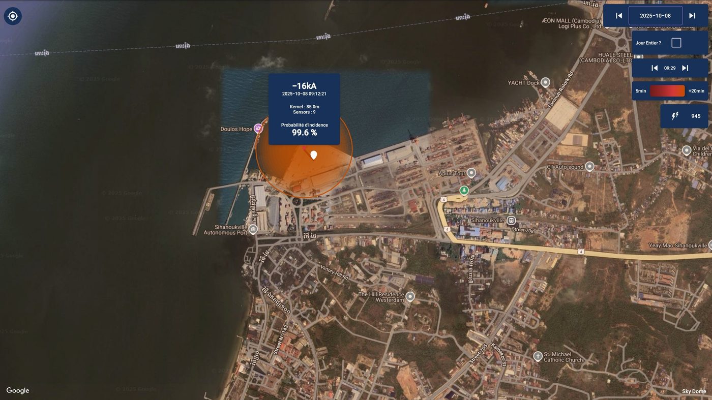
- A displayed point corresponds to an estimated location, surrounded by an area of uncertainty that can reach several hundred meters; it therefore does not designate the exact starting point of the fire.
- The apparent distance must be interpreted in light of the available quality information.
- A temporal correlation makes a hypothesis relevant, without eliminating other causes.
- The absence of any visible impact is not, in itself, sufficient to rule out any involvement of lightning.
- Persistent current discharges, often of positive polarity, are recognized as more likely to ignite vegetation: this is a factor of probability, never proof.
Let's reject the shortcut "close therefore responsible"
For example, an impact recorded near a power line may justify examining that area. However, it does not prove either that the line was directly affected or that it triggered the fire. On-site observations, operating hours, and alternative hypotheses remain essential.
How to cross-reference chronology, traces, and lightning data
The approach described in Michigan begins with a review of existing documentation, then is refined through on-site investigations. Investigators trace the fire back to its source, interpreting factors such as the direction of combustion and the charring of vegetation. These observations require specialized expertise; they are not an investigative method that can be improvised by the operator.
Prepare a document that is easy to understand for specialists
- Establish the chronology: time of discovery, first signs, alarms and known operations, with the time zone.
- Identify the perimeter: coordinates, plans, site boundaries and location of equipment.
- Keep the documents: authorized photographs, operating logs and references to weather sources.
- Bring lightning events closer to the relevant period, without arbitrarily reducing the search to the minute of discovery.
- Separate documented facts, working hypotheses, and validated conclusions.
Indeed, the time a fire is noticed is not necessarily the time it started: a fire of lightning origin can smolder for several days in organic matter before becoming visible. However, this possibility does not automatically allow us to attribute a fire to a past storm. The timeframe for analysis must remain justified by the context and the elements of the investigation.
Preserve the evidence without exposing the teams
The priority remains the safety of people and the work of emergency services. Therefore, the operator must not enter a hazardous area to photograph a suspected lightning strike. Remote data collection may begin while access to the site remains prohibited.
Similarly, any changes to the site following an incident must be coordinated with the relevant authorities. Therefore, properly dated and stored information can be more useful than a sensational but unverifiable interpretation.
Strike Radar: Leveraging the impacts after the storm, without overpromising
Strike Radar is a documented lightning data analysis service that allows, among other things, the interpretation of lightning strikes after a storm. It provides insight into activity around a chosen area; however, it does not detect fires and does not replace emergency services or causal investigations.
Clearly distinguish between meteorological information and equipment diagnostics
The service can send an email for any cloud-to-ground strike within the chosen area, regardless of intensity. However, this email only reports a lightning event within that area; it does not certify that specific equipment was struck or that any damage occurred.
- The map helps to locate the events to be examined.
- Timestamping helps to link different observations.
- The displayed characteristics should be read with their limitations.
- Diagnosing the installation requires appropriate checks, for example reading a direct lightning strike counter.
LPS Manager , for its part, is involved in monitoring installations and supervising connected products. This distinction avoids confusing meteorological data, equipment status, and expert conclusions.
Transforming this feedback into operational readiness
Whether it's an industrial site in Europe, an isolated infrastructure in Africa, or an energy facility in South America, the question remains the same: how to make information usable after an event? Thus, the Black River case study is relevant beyond the American forest. It demonstrates the value of an organization capable of combining complementary sources without conflating their scope.
Three useful preparations before the next storm
- Define who collects the data, who authorizes access, and who requests expertise.
- Keep up-to-date plans, emergency contacts, equipment references and lightning protection documents.
- Establish a common method for dating findings and distinguishing provisional information from conclusions.
Furthermore, analyzing an incident never replaces the need for appropriate site protection. The International Electrotechnical Commission's (IEC) IEC 62305 (2024 edition) framework provides a structure for lightning protection of installations; however, protecting a building does not prevent all fires in the surrounding natural environment. Fire prevention measures and local procedures remain essential. Finally, periodic checks of the lightning protection system allow for documentation of its condition before and after an event.
In conclusion, Black River illustrates attribution based on the correlation between physical evidence and lightning data. A map contributes to the analysis but does not constitute standalone proof of causality. Strike Radar illuminates post-storm activity, while LPS Manager supports facility monitoring and the supervision of connected products. To prepare your organization, align your documentation needs with LPS services before the next incident.
Frequently Asked Questions
What did the Michigan DNR confirm on October 18, 2026 regarding the Black River Fire?
The Michigan Department of Natural Resources (DNR) confirmed that lightning caused the Black River Fire and the Craig Lake Fire in Michigan's Upper Peninsula. As of that date, the cause of the Ridge Fire remained under investigation.
How was the lightning origin of the Black River fire established?
After reviewing documentation of meteorological events and then ground observations, investigators noted signs of charring on a group of cedar trees, corroborated by lightning strike mapping.
Is a lightning strike map sufficient to prove the origin of a fire?
No. A reported impact is an estimated location, surrounded by a zone of uncertainty that can extend to several hundred meters. It must be cross-referenced with physical evidence, the chronology, and the conclusions of a competent investigator.
What is the purpose of Strike Radar after a thunderstorm?
Strike Radar helps analyze storm activity after the fact: it sends an email for each cloud-to-ground strike detected in the chosen area, without a threshold, allowing users to locate and date the events to be examined. It does not constitute proof of cause or a diagnosis of the installation.
Primary sources: Michigan DNR, official confirmation October 18, 2026 ; Michigan DNR, alert point October 22, 2026 ; Strike Radar presentation (link above).