
Every year, more than a billion lightning strikes hit the planet. In Europe, America, Asia, the Middle East, Africa—on every continent, industrial facilities, critical infrastructure, and equipment of all kinds are directly or indirectly affected by lightning. Yet, in most cases, their managers don't know if their site has been struck, when, or with what intensity. Strike Radar is the professional service from LPS France that transforms this uncertainty into certified and actionable data—without any on-site equipment installation, anywhere in the world. No sensors to buy. Immediate access to the history of lightning strikes, wherever your site is located.
How does Strike Radar work?
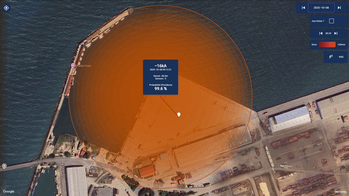
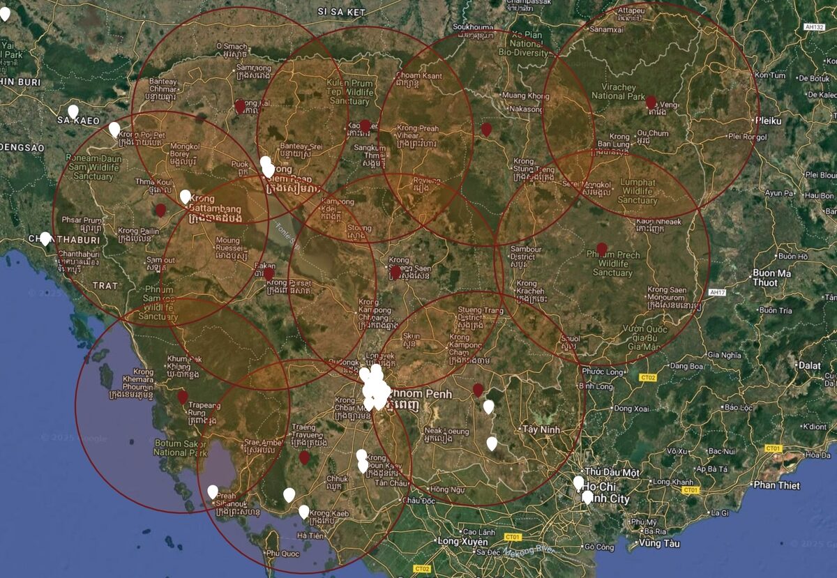
Strike Radar is a service for recording and certifying lightning strikes. In practical terms, it allows any facility manager to know if lightning has struck within a radius of up to 100 km around their site — with hourly, geographical and physical accuracy.
The service relies on the GLD360+ global sensor network . This network uses VLF/LF detection technology, which captures the electromagnetic signature of each lightning strike. Multi-sensor triangulation ensures rigorous cross-validation of each strike. The resulting data complies with IEC 62793:2020 and can be used for risk assessment according to IEC 62305-2:2024 .
For each detected impact, Strike Radar provides:
- The precise GPS coordinates of the impact
- The exact date and time (certified timestamp)
- Current intensity in kiloamperes (kA)
- Polarity (positive or negative)
- The estimated distance from the monitored site
- The number of sensors that have validated the impact
Three professional deliverables for each situation
Strike Radar does more than just display raw data. It generates three types of deliverables that can be used directly by lightning protection professionals.
The Keraunic Report
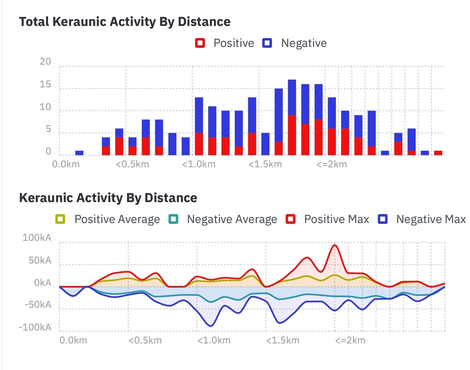
The lightning report is a precise and detailed statistical analysis of lightning activity within a 2 km of the site, over a defined period. It centralizes all measured data: chronological history of strikes, peak intensity (kA), frequency of occurrence, spatial distribution, and exact distances. It is not a national estimate—these are statistics derived from actual recorded strikes.
The IEC 62305-2:2024 models induced effects (surges, LEMP coupling) up to approximately 350 m for standard equipment, and up to 1 km for finish lines. LPS France shows that between 1 and 2 km , impacts can still cause destructive induced surges or excessive fatigue of surge protectors and sensitive equipment. The keraunic report therefore fully covers this critical zone.
It is a crucial tool for:
- To establish a lightning risk study based on real data
- Justify an upgrade to the Lightning Protection Level (LPL)
- Prepare a preventive maintenance plan for the end customer
- Ng data to calculate Nsg (ground lightning density, IEC 62305-2:2024 parameter) via the LPS France v2.0
The NSG (number of ground impacts per km² per year, 10 × 10 km grid) is indeed the normative reference for assessing the level of risk. Strike Radar allows it to be calculated from actual data measured on site — and not from generic statistical tables.
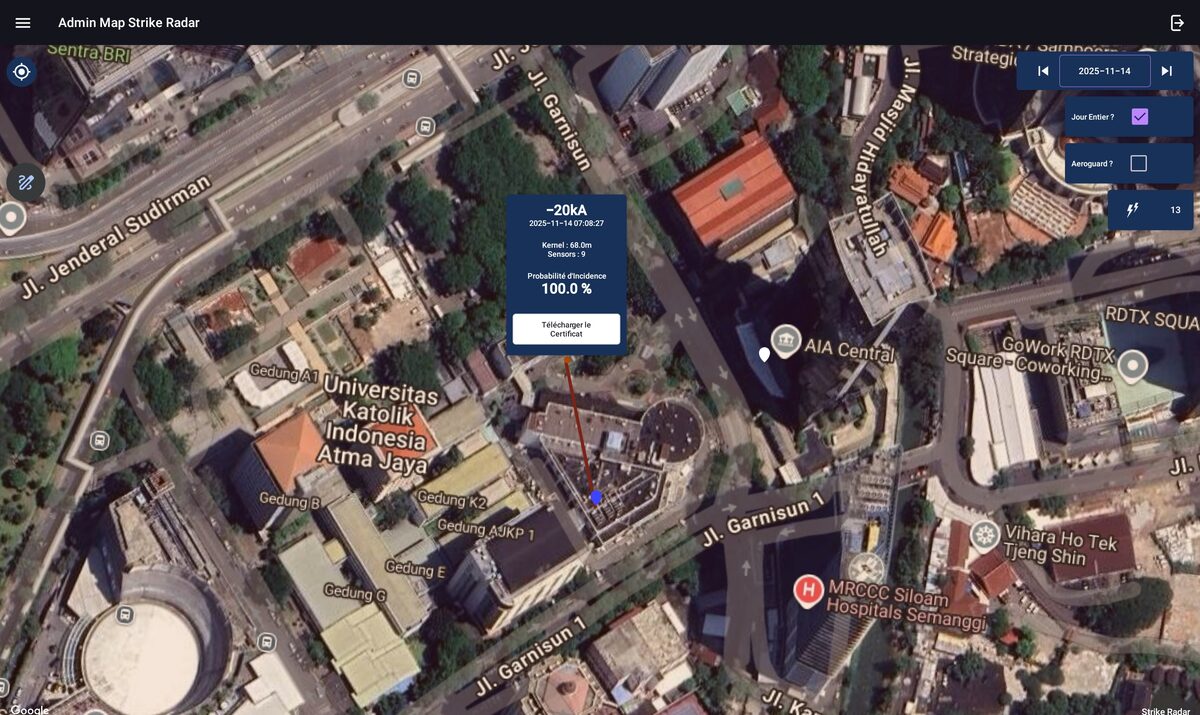
The lightning strike certificate
When a lightning strike is detected near a facility, Strike Radar generates a certificate . This document officially confirms the strike, including the date, time, intensity, and polarity. It is corroborated by multiple sensors and constitutes certified evidence, usable in various contexts:
- Claim filed with an insurer
- Justification for post-impact maintenance intervention
- Regulatory traceability for establishments subject to audit (ICPE, ERP, IGH)
- Documentation of a technical expertise report
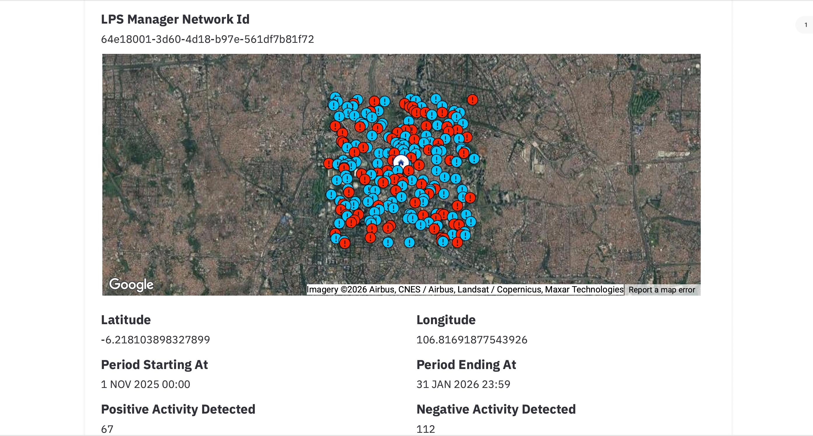
The Nsg — ground lightning density
The international standard IEC 62305-2:2024 defines the method for assessing lightning risk. It is based on several parameters, including the local Nsg — density of ground strikes per km² per year, on a 10 × 10 km grid.
In many risk studies, this parameter is estimated from generic regional tables (Ng). Strike Radar goes further: by providing Ng from real measurements over a minimum of 3 months of history, it makes it possible to calculate an Nsg anchored in the physical reality of the site — much more accurate than national averages.
This data becomes an objective argument for:
- Validate or reconsider the installed level of protection
- Update an existing risk study
- Strengthening the credibility of a technical report submitted to the client
Note: The conversion Ng → Nsg (Km factor = 2.0 according to IEC 62305-2:2024) must be applied before any use in a certified risk assessment. These values are a complementary, not a stand-alone, indicator.
Why is Strike Radar changing the lightning maintenance logic?
NF C 17-102:2011 (§ 8) and IEC 62305-3 (§ 7) periodic inspections exceptional verifications , triggered after each lightning strike observed or detected on the installation — complete and mandatory for LPL levels I and II.
Until now, determining whether a facility had been struck required communication equipment attached to the system itself—additional equipment that wasn't always in place. And for surrounding impacts—those that didn't directly strike the structure but could have caused induced surges on electrical and data networks, or mechanical effects (shock waves, electromagnetic induction) on equipment—there simply was no accessible source of information.
Strike Radar removes these two obstacles. By consulting the history of impacts within a 300m radius around the site, you have — with date, time and intensity — all the information necessary to decide if a regulatory verification is required: whether it is a direct impact on the installation or a nearby event that may have affected equipment and networks.
early streamer emission lightning rod ( Paraton@ir or Ellips® Ellips LPS LPS France ) can:
- Check Strike Radar and confirm that an impact occurred 300 m from your location
- Trigger a priority inspection of its down conductors and grounding points
- Download the lightning strike certificate to create your traceability file
- Justify the maintenance expense to management with dated and certified proof
A service that requires no installation and is immediately accessible
One of Strike Radar's major advantages is its ease of implementation. Unlike a physical surveillance system, no hardware needs to be installed on-site . The service is entirely cloud-based, continuously powered by the GLD360+ network.
Getting started is immediate. Simply define the site(s) to monitor (GPS coordinates or address), set the desired monitoring radius (up to 100 km), and access the data via the online interface. PDF reports can be downloaded directly from the platform.
LPS France monitoring ecosystem : Strike Radar data can be consulted in addition to field data from Contact@ir System , which detect impacts directly on the head of the Paraton@ir ® or the ESE Ellips .
Strike Radar in the LPS France ecosystem
LPS France offers a complete lightning protection chain, from equipment to monitoring. Strike Radar is part of this comprehensive vision:
- Physical protection : Paraton@ir ® and Ellips ® (PDA with initiation device, standards NF EN 62305 / IEC 62305:2024 and NF C 17-102:2011)
- Field detection : Contact@ir System — detects impacts directly on the ESE head, 868 MHz radio transmission
- Contact@ir MD (integrated IoT/SIM version) — for sites without local network (isolated sites, wind turbines, telecom towers, ICPE facilities that are difficult to access)
- Cloud monitoring : LPS Manager — SaaS for facility and maintenance management, integrating Contact@ir
- Certified data : Strike Radar — historical record of impacts on the GLD360+ network, reports and PDF certificates
- Protection calculation : LPS Designer Pro — SaaS for calculating protection levels according to IEC 62305-2:2024, integrating Strike Radar data (actual measured Nsg) to refine lightning risk calculation parameters
- Preventive alert : Sky Sentinel — real-time weather monitoring and storm warning, compliant with IEC 62793:2020
- Personal protection : AtmoGuard — free mobile lightning alert app (+10,000 downloads) — App Store (iOS) · Google Play (Android)
post-impact evidence (something happened, here is the data). Sky Sentinel pre-impact alerts (a storm cell is approaching). Contact@ir detects the impact directly on-site . Together, they constitute an unprecedented level of traceability and control for lightning protection professionals.
To go further in managing your lightning protection installations, also discover the Dongl@ir Contact@ir data collection ) and the Rout@ir (fixed 868 MHz Radio receiver — connected to the local network (LAN/WiFi) for continuous monitoring).
Conclusion
Strike Radar addresses a long-overlooked need in lightning risk management: access to objective, dated, and certified evidence of events. By combining the power of the GLD360+ network, compliance with IEC 62305-2:2024 standards, and the simplicity of a cloud-based, installation-free service, Strike Radar empowers lightning professionals to transform every storm event into an informed decision—and a documented argument.
Whether it is to justify a maintenance intervention, to compile an insurance file or to refine a risk study, lightning data has never been so accessible and usable.
Strike Radar is available on demand
Strike Radar is a cloud subscription service — no hardware to install. You get immediate access to lightning detection data, for a single site or an entire park, anywhere in the world.
To learn more about access requirements, request a personalized demonstration, or obtain trial access:
Are you already a subscriber? Access your Strike Radar account