The 2026-2027 El Niño is shaping up to be one of the most intense episodes ever recorded, and the forecasts published in October 2026 now specify its magnitude. For site operators, however, the relevant question is not whether "El Niño causes lightning." Indeed, thunderstorm activity remains a constant risk; El Niño primarily acts as an amplifying factor that redistributes conditions favorable to thunderstorms.
On October 21, 2026, Futura compiled seven maps and images illustrating the global threat posed by this event. We consulted the primary sources cited: NOAA, World Meteorological Organization (WMO), Copernicus, and Météo-France.
This third installment completes our series. The mechanism is explained in El Niño: Understanding the Phenomenon and its Influence on Thunderstorms, and the link with electrical activity in Thunderstorms and Lightning: How El Niño Changes Global Risk. Here, we summarize what the maps show for 2026-2027, and then what site managers, particularly international ones, need to check.
What do the October 2026 El Niño forecasts say?
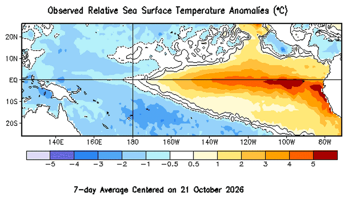
Forecasts are converging: El Niño is established, it continues to strengthen, and its peak is expected around December 2026. A weakening is then predicted for spring 2027, with a likely return to neutral conditions before summer. However, its climatic effects may extend beyond the oceanic peak.
Oceanic indices at exceptional levels
The Niño-3.4 index is the deviation of sea surface temperature in the central and eastern equatorial Pacific from normal. It serves as the primary indicator of the phenomenon. However, its current values are very high:
- +2.1 °C for Niño-3.4 and +3.9 °C for Niño 1+2 over the past month, with anomalies greater than +4 °C in the eastern Pacific (NOAA CPC, bulletin of October 8, 2026);
- +2.4 °C for Niño-3.4 in the weekly update of October 19, 2026 (NOAA CPC, weekly point);
- around +3.7 °C expected on average over October-December, compared to a previous record of +2.6 °C at the end of 2015-beginning of 2016 (WMO, 8 October 2026).
“Super El Niño”: a media term
The term "super El Niño" is a media term, without an official scientific classification. The WMO refers to a "very strong" El Niño, meaning an anomaly of at least +2°C. Furthermore, NOAA assesses intensity using the Relative Oceanic Niño Index (RONI), which adjusts for the effect of global ocean warming.
Specifically, the published probabilities are as follows:
- 100% chance of a very strong episode (RONI ≥ +2.0 °C) in October-December 2026, then 96% in November-January and 81% in December-February (NOAA CPC, intensity probabilities, October 2026);
- 83% chance, in October-December, of a historic episode exceeding +2.5 °C, i.e. beyond all El Niño events observed since 1950 (NOAA CPC, October 8, 2026);
- a near-certain persistence until February 2027, according to the consensus of thirteen forecasting centers coordinated by the WMO;
- an episode close to its peak, but whose impacts "may continue to intensify" during the winter (NOAA GFDL, October 7, 2026).
What the maps show: a redistributed, not uniform, risk
Seasonal maps do not show a general increase in thunderstorms. On the contrary, they describe a shift in areas that are wetter and drier than normal. Therefore, each site must be analyzed according to its region and season.
Wetter regions, drier regions
For October-December 2026, the WMO seasonal update identifies, in particular:
- wetter than normal conditions over the central and eastern equatorial Pacific, the Greater Horn of Africa, southeastern South America, parts of North America south of 45° N, Central Asia and coastal East Asia;
- drier conditions over the Indian subcontinent, southern Central America, parts of the Caribbean, northwestern South America and the western Pacific;
- droughts already exacerbated in Central America and Indonesia (Météo-France, October 2, 2026).
The Copernicus seasonal forecasts, reported by Futura, show the same pattern of regional anomalies. However, a rainfall anomaly is not the same as a lightning anomaly. Thus, a drier season may have fewer thunderstorms, but more lightning cells.
And what about Europe?
For Western Europe, Météo-France describes a weak average signal: slightly more rain and milder temperatures at the start of winter. However, these effects are not systematic, and the agency specifies that they mainly concern the tropical and subtropical overseas territories.
- French Guiana, Antilles, Polynesia or New Caledonia: follow the bulletins of the local meteorological services (Météo-France, overseas impacts);
- Continental Europe: maintain the usual verification schedule, without waiting for an El Niño signal.
Why lightning remains a constant risk
Lightning is an electrical discharge produced primarily by deep convective clouds. Convection is the upward movement of warm, moist air that feeds these clouds. Therefore, anything that alters the available heat and moisture can change the electrical activity.
El Niño, an amplifier among others
El Niño does not create thunderstorms; it shifts and strengthens, depending on the region, the environments that are conducive to them. For example, the Niño-3.4 index is significantly correlated with local lightning activity in 53% of the areas studied for at least one season (Dowdy, Scientific Reports, 2016). Furthermore, the WMO notes that the current ocean temperature is the warmest ever recorded, leaving more energy available.
- The peak of El Niño, expected between November and February, coincides with the storm season in many regions of the Southern Hemisphere.
- Sites in South America, southern and eastern Africa, and Southeast Asia are therefore the first to be affected.
- Everywhere else, the basic risk remains: an unprotected site remains exposed, El Niño or not.
The best indicator remains local
Ground lightning density, denoted Ng, is the number of lightning strikes per square kilometer per year. This density, along with the site's configuration, informs lightning risk analysis. In other words, a global map provides context, while local data guides decision-making.
What lightning checks should be planned before the storm season?
Before the storm season, a site must verify its direct protection, grounding, surge arresters, and maintenance plan. The international reference framework is the IEC 62305 series (2024 edition), supplemented by locally applicable regulations. Each measure must then be adapted to the specific site analysis.
- Direct protection : check the condition of lightning rods, spikes and masts. Lightning rods with early streamer emission (ESE) devices, such as Paraton@ir or Ellips, are sized according to NF C 17-102:2011 and a site study.
- Downhill drivers : check continuity and fixings, especially after storms or heavy rain.
- Grounding : measure the resistance of the grounding electrodes and check the Equipotential Spark Gap. Indeed, soil moisture affects its resistivity, which is important in regions experiencing alternating periods of drought and heavy rainfall.
- Surge arresters : check the condition and coordination of surge protections (see our section on indirect lightning protection).
- Meters and tests : reading impact counters, such as the Compt@ir, and testing ESEs. The system Contact@ir allows testing Paraton@ir without going up onto the roof.
- Instructions : Update the procedures for stopping external activities and the lists of recipients of alerts.
For a multi-site group, it is useful to prioritize sites located in the regions indicated by the seasonal maps. Furthermore, overseas sites deserve their own calendar.
Monitor storm activity using LPS ecosystem tools
Physical protection alone is not enough to ensure the security of a site. That's why the LPS Platform brings together complementary tools, each with a specific role.
- Sky Sentinel provides continuous monitoring around a site, updating every 60 seconds, and sends storm alerts to designated recipients. It helps determine when to interrupt outdoor activities without triggering automatic action.
- Strike Radar allows you to check after a storm if any impacts have been recorded around a site, to analyze their history and to obtain keraunic reports and lightning strike certificates.
- LPS Manager, the application for monitoring connected products LPS France, centralizes the status of Paraton@ir meters Compt@ir, with a time-stamped history per installation.
Sky Sentinel is not a protection device falling under NF C 17-102 and IEC 62305. It is a lightning monitoring and warning service compliant with IEC 62793.
In summary
Ultimately, El Niño 2026-2027 is expected to reach a historic level, peaking around December 2026 and with effects extending into 2027. Its impacts, however, remain regional: they primarily affect the Pacific, the Americas, Southeast Asia, East and Southern Africa, as well as overseas territories. Therefore, lightning protection remains a constant necessity, which this cycle simply makes more urgent at certain sites. Now is the ideal time to check power supply units (PSUs), grounding systems, and surge protectors, and then organize monitoring. To prepare your sites, contact LPS France.
FAQ
What is a "super El Niño"?
It's a media term referring to a very intense episode, generally with a temperature anomaly greater than +2°C in the equatorial Pacific. The WMO prefers the expression "very strong" El Niño. The 2026-2027 episode could surpass the record of 2015-2016.
Will El Niño increase lightning in mainland France?
According to Météo-France, its influence on Western Europe is weak and not systematic. The most significant effects are felt in tropical regions and overseas territories. However, the usual risk of lightning remains and warrants verified protection.
How long will episode 2026-2027 last?
The WMO considers its persistence almost certain until February 2027. NOAA then forecasts a weakening in the spring and a likely return to neutral conditions around May-July 2027. Nevertheless, the impacts may continue after the oceanic peak.
Sources
- NOAA Climate Prediction Center, ENSO Diagnostic Discussion, October 8, 2026.
- NOAA Climate Prediction Center, ENSO Strength Probabilities, October 2026, and weekly update of October 19, 2026.
- NOAA GFDL, October 2026 El Niño Predictions, October 7, 2026.
- World Meteorological Organization, press release of October 8, 2026 and El Niño/La Niña Update of September 3, 2026.
- Météo-France, “El Niño could reach an intensity unseen since 1950”, October 2, 2026, and “El Niño: what impacts on overseas territories?”.
- Copernicus Climate Change Service, seasonal forecasts.
- Dowdy AJ, Scientific Reports, 2016.
- Futura, “The worst is yet to come: 7 maps and images…”, October 21, 2026.