El Niño is nearing its peak, and the storms of October 2026 already show one thing: its effects don't follow a simple pattern. Indeed, historic floods are hitting the Paraná basin, Australia is experiencing a very wet October despite a signal that was supposed to dry it out, while Indonesia is still waiting for its rains.
For site operators, the lesson is clear. Storm activity remains a constant risk; El Niño acts as an amplifying factor, but other climatic drivers also determine the intensity of storms locally. Therefore, local data must guide lightning protection.
This fourth installment continues our series. The mechanism is explained in El Niño: understanding the phenomenon and its influence on thunderstorms, the link with lightning in Thunderstorms and lightning: how El Niño changes global risk, and the October forecasts in El Niño 2026-2027: what the forecasts say for lightning.
What is the status of El Niño at the beginning of November 2026?
In early November 2026, El Niño continued to strengthen, with its peak still expected around December. Ocean indices reached unprecedented levels in several datasets. However, agencies reiterate that a very strong ocean signal does not automatically lead to strong impacts everywhere: regional effects remain probabilistic.
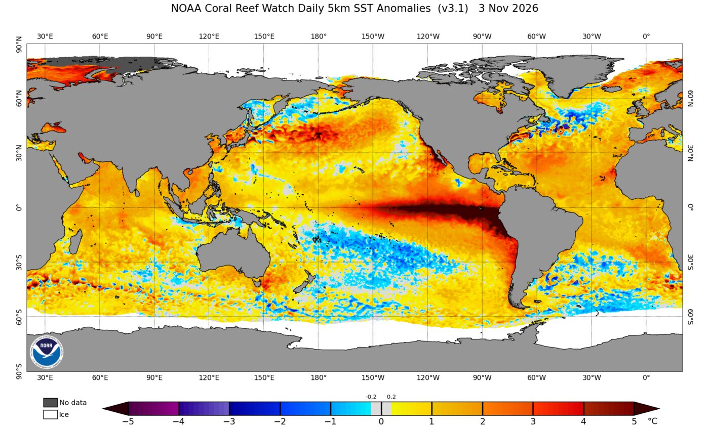
Specifically, the latest published figures are as follows:
- NOAA (as of November 2, 2026) : Weekly anomaly of +2.5°C for the Niño-3.4 index, +3.7°C for Niño-3 and +4.6°C for Niño 1+2, off the coast of South America (NOAA CPC, ENSO: Recent Evolution, Current Status and Predictions, November 2, 2026).
- Australian Bureau of Meteorology (BoM, October 27, 2026) : The relative Niño3.4 index reached +2.88°C in the week ending October 25, a record for its weekly series which began in 2008. The BoM specifies, however, that the longer monthly series remains below records (BoM, ENSO monitoring).
- World Meteorological Organization (WMO, October 21, 2026) : average anomaly of about +3.8°C expected for November-January, with a peak around December and strong confidence in models (WMO, Global Seasonal Climate Update November-December-January).
- Next event : NOAA will publish its monthly ENSO bulletin on November 12, 2026.
The Niño-3.4 index is the difference in sea surface temperature in the central and eastern equatorial Pacific. Furthermore, the expression "super El Niño" is a media term: the WMO refers to a "very strong" El Niño, exceeding approximately +2°C.
Why doesn't El Niño produce the same storms everywhere?
El Niño doesn't create thunderstorms; it shifts tropical convection, meaning the updrafts of warm, humid air that fuel storm clouds. As a result, some regions receive more moisture, while others receive less. Furthermore, other climate factors can either reinforce or counteract this signal, depending on the region.
Recent observations clearly illustrate this:
- A clear shift in convection : over the last 30 days, NOAA has observed strengthened convection from the central Pacific to the east, but repressed over the Philippines, Indonesia and Papua New Guinea (NOAA CPC, November 2, 2026).
- A second driving force in the Indian Ocean : the Indian Ocean Dipole (IOD) is a temperature difference between the west and east of this basin. It has been in a positive phase for seven weeks, at +0.69 °C at the end of October (BoM, October 27, 2026).
- Very warm local seas : waters are up to 3°C above normal in southeastern Australia, providing additional moisture to the atmosphere (BoM, October 27, 2026).
Thus, the BoM itself summarizes the situation: a strong El Niño signal does not necessarily mean strong impacts on Australian rainfall and temperatures. In other words, the global map shows a trend, but not a site-specific diagnosis.
What do the storm episodes of October 2026 reveal?
October 2026 presented three contrasting situations. Subtropical South America experienced rainfall consistent with the classic El Niño pattern. Australia, on the other hand, recorded a very rainy and stormy month. Finally, Indonesia suffered a prolonged drought. Each case therefore calls for a different approach to preparing facilities.
South America: Floods in the Paraná basin
In mid-October, torrential rains linked to El Niño caused the Paraná, Uruguay, and Iguazu rivers to overflow. For example, the Paraná reached 4.7 meters in Ituzaingó, Argentina, and more than 2,000 people were evacuated in Ayolas, Paraguay (Associated Press, as reported by The Hindu, October 17, 2026). Furthermore, the Brazilian meteorological service forecasts above-average rainfall in southern Brazil through December.
Australia: A very wet October, despite El Niño
According to official figures, rainfall in October 2026 exceeded the 1961-1990 national average by 91%, ranking ninth since 1900. Queensland experienced its second wettest October on record (+194%). Additionally, severe thunderstorms affected New South Wales, the Australian Capital Territory, and Victoria on October 3 (BoM, October 2026 Monthly Summary, published November 2).
Southeast Asia: Drought and delayed rainy season
Conversely, Indonesia is experiencing a prolonged drought. In West Kalimantan, the receding waters of the Kapuas River are disrupting transportation, and the Indonesian meteorological agency expects the rainy season to start in November, instead of October (Reuters, October 19, 2026). The first thunderstorms will therefore fall on very dry ground.
What are the consequences for lightning protection systems?
Floods and droughts do not affect electrical installations in the same way. After a flood, the integrity of grounding systems, connections, and electrical equipment must be checked. After a drought, the resistance of grounding electrodes may increase. In both cases, an inspection before the storm season is essential.
The international reference framework remains the IEC 62305 series (2024 edition), supplemented by locally applicable texts. Specifically, here are the points to prioritize:
- After a flood : check manholes, shut-off bars and Equipotential Spark Gap, then look for corrosion and mud deposits on buried connections.
- After a drought : measure the resistance of the grounding system. Indeed, dry soil conducts electricity less well; a degraded value should be analyzed before the first storms.
- Direct protection : check the fastening of the points, masts and down conductors after wind events. Lightning rods with early streamer emission (ESE) devices, such as the Paraton@ir or theEllips, are checked according to NF C 17-102:2011.
- Surge protectors : check their status indicators and coordination, especially if panels have been exposed to moisture (see our section on indirect lightning protection).
- Impact counters : reading the counters, such as Compt@ir, in order to date recent requests.
Furthermore, the Southern Hemisphere storm season is just beginning. Sites in South America, Southern Africa, Oceania, and tropical overseas territories should therefore be checked first.
How to monitor the actual storm activity around each site?
Since the climate signal varies from region to region, the decision must be based on data measured around each site. The tools of the LPS ecosystem have distinct roles: analyzing the impacts after a storm, monitoring the approach of storms, and organizing the long-term monitoring of installations.
- LPS Strike Radar allows you to check, after a storm, whether lightning strikes were recorded around a site, analyze their history, and obtain lightning reports and certificates. Our article " Strike Radar: Documenting Lightning Activity at a Site" details this process.
- Sky Sentinel provides continuous monitoring around a site, updating every 60 seconds, and sends storm alerts to designated recipients. It helps determine when to interrupt outdoor activities, without triggering automatic action.
- LPS Manager centralizes the monitoring of lightning protection installations, their verifications and the status of connected Paraton@ir and Compt@ir.
- LPS Designer Pro helps to perform lightning risk analysis according to IEC 62305-2, based on local lightning density.
Sky Sentinel is not a protection device falling under NF C 17-102 and IEC 62305. It is a lightning monitoring and warning service compliant with IEC 62793.
In summary
Ultimately, El Niño is approaching its peak with record indices, and its effects are confirmed, but very unevenly. October 2026 demonstrated this: floods in South America, rain and thunderstorms in Australia despite El Niño, and drought in Indonesia. Therefore, lightning protection remains a constant necessity, made even more urgent by this cycle at certain sites. The best approach is to check grounding and protection systems before the storm season, and then monitor actual activity site by site. With over 25 years of experience in lightning protection (since 2000), LPS France supports you in preparing your sites.
FAQ
Why did Australia experience a rainy October during El Niño?
El Niño typically dries out much of Australia during the southern spring. However, in October 2026, warmer-than-normal seas around the continent, up to +3°C in the southeast, brought additional moisture. The result: the ninth wettest October since 1900, according to the BoM.
Will El Niño increase lightning in mainland France?
According to Météo-France, its influence on Western Europe is weak and not systematic; the most pronounced effects are felt in tropical regions and overseas territories. However, the usual risk of lightning remains and warrants verified protection.
When is El Niño 2026-2027 expected to reach its peak?
The WMO and the BoM predict the peak will occur around November-December 2026. According to the BoM, all models then maintain El Niño above thresholds until the austral autumn of 2027, around March-May. However, the impacts on thunderstorms may persist after the oceanic peak.
Sources
- NOAA Climate Prediction Center, “ENSO: Recent Evolution, Current Status and Predictions”, November 2, 2026, and ENSO Diagnostic Discussion of October 8, 2026.
- Bureau of Meteorology (Australia), ENSO monitoring and Southern Hemisphere oceans, October 27, 2026.
- Bureau of Meteorology (Australia), “Australia in October 2026”, monthly report published on November 2, 2026.
- World Meteorological Organization, Global Seasonal Climate Update for November-December-January 2026-2027, October 21, 2026.
- Associated Press, “El Nino rains flood South America”, reprinted by The Hindu, October 17, 2026.
- Reuters, “El Niño-powered drought leaves Indonesian palm farmers high and dry,” October 19, 2026.
- Météo-France, “El Niño: what are the impacts on the overseas territories?”.