
Formation of a storm cloud
The presence of unstable, humid and warm air masses leads to the formation of storm clouds: cumulonimbus.
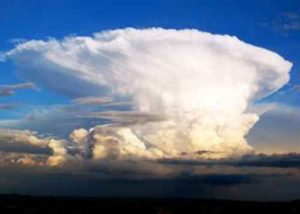
This type of cloud is very well developed, both horizontally (approximately 10 km in diameter) and vertically (up to 15 km). Its distinctive shape is often compared to the profile of an anvil, as it possesses horizontal upper and lower planes. The existence of very significant temperature gradients within a cumulonimbus cloud (the temperature can drop to -65°C in the upper part) results in very rapid updrafts; this leads to the electrification of water particles.
In a typical storm cloud, the upper part, made up of ice crystals, is generally positively charged, while the lower part, made up of water droplets, is negatively charged. Through this influence, the lower part of the cloud causes the development of charges of opposite signs (therefore positive) on the ground nearby.
Electrical exchanges occur within this cloud, but also between different clouds of the same type. This results in lightning.
However, the cumulonimbus also behaves like a gigantic flat cloud-ground capacitor, the intermediate distance of which often reaches 1 to 2 km.
The electro-atmospheric field at ground level, which is on the order of a hundred volts per meter (in good weather), is then reversed and can reach an absolute value of 15 to 20 kV/m when a ground discharge is imminent.
This discharge, when it occurs, is called a lightning strike.


Formation of a lightning strike
Observation without specific equipment does not allow us to discern the phases of the formation of a lightning strike.
However, the following phenomena occur in most lightning strikes:
- A luminous descending leader starts from a point in the cloud and advances approximately 50 m at a speed of 50,000 km/s.
- A second descending tracer starts from the same point, follows the previous path with a comparable speed, passes the stopping point of the first by a similar distance and disappears in turn.
The process is repeated until the head of the last tracer reaches within a few dozen meters of the ground.
As soon as the head of a descending leader approaches the ground, a cloud-ground connection is established with the electrostatic efflux (corona effect) from the ground. An ascending leader then appears from the ground towards the cloud: this is the initiation phenomenon .
Note: The "magnitude" of the initiation is inversely related to the distance from the storm cloud. This is why a tall building will be more "easily" struck by lightning.
The meeting of the two phenomena (descending and ascending tracer) constitutes the main discharge (lightning strike), which can be followed by a series of secondary discharges traveling through the channel ionized by the main discharge of a single tracer.
In an average negative lightning strike, the current intensity value is close to 25,000 amps.
 lightning rods")
The characteristic phases of the evolution of a negative lightning strike:
1. Descent of the tracer in steps.
2. Initiation of the ascending tracers.
3. Meeting between an ascending tracer and the descending tracer in steps, then return flow of the arc current.